


 Live Chat
Table of Content
With the introduction of cloud, the way data is stored and accessed is truly transformed all around the globe. The world has witnessed a massive transition from traditional hosting towards cloud hosting. Cutting-edge features such as high scalability, enhanced security, higher performance, and lower downtime have made cloud hosting the best choice for organizations. Along with cloud hosting, GIS cloud hosting is making its way and proving to be a game changer in the digital landscape. As the aerospace industry is making significant advancements, satellite data is becoming more accessible each passing day.
GIS cloud hosting, which has revolutionized GIS technology in the age of cloud computing, is essential for sectors like environmental management and urban planning. This advancement offers unparalleled flexibility, scalability, and collaborative capabilities, signaling a paradigm change. The blog explores the intricate world of GIS cloud hosting, looking at its development and emphasizing its salient characteristics, advantages, difficulties, and revolutionary power over geographical data administration. GIS cloud hosting is a fundamental component that is transforming the way that geographical information is seen, processed, and utilized in a variety of industries in an era when data is essential for making decisions.
- The size of the worldwide Geographic Information System (GIS) market was estimated at USD 8814.84 million in 2022, and it is anticipated to grow at a compound annual growth rate (CAGR) of 8.28% to reach USD 14210.1 million by 2028.
- At a share of 24.1% in 2021, the government sector was the biggest user of GIS cloud hosting.
- The most well-known sectors that use GIS cloud hosting include natural resources, automotive, energy & power, government, and defense & intelligence.
Understanding Geographic Information System (GIS)
GIS (geographic information system) technology is a potent instrument that is revolutionizing our approach to managing geographical data. It allows users to see, evaluate, and comprehend correlations, patterns, and trends in different landscapes by fusing information with geographical data. In order to collect, organize, and present geographic information, GIS technology integrates hardware, software, and data. This process offers important new perspectives for decision-making in domains such as environmental science, agriculture, and urban planning. It makes it easier to comprehend geographical aspects dynamically, which promotes wise decision-making and efficient resource management. For businesses that depend on location-based data to improve productivity, sustainability, and overall decision-making, GIS technology has become essential.
The Evolution of GIS Cloud Hosting
The development of GIS cloud hosting represents a paradigm change in the handling of geographical data. GIS has historically run on local servers, which have limited scalability and accessibility. GIS moved to hosted systems with the rise of cloud computing, which provided unmatched flexibility and teamwork. Spatial data may be easily stored, processed, and shared by users of cloud-based GIS. This innovation improves scalability so that businesses can adjust to changing workloads. GIS cloud hosting promotes cooperation and real-time data sharing by democratizing access. The way that GIS technology and cloud hosting interact dynamically has transformed spatial data analytics and established it as a key component of decision-making across a range of businesses.
Features and Benefits of GIS Cloud Hosting
High Scalability
Because GIS cloud hosting offers on-demand scalability, businesses can adjust to shifting workloads. This functionality is essential for managing different degrees of data processing needs. In order to maximize cost efficiency, the cloud architecture can dynamically assign or release resources during times of high spatial analysis activity or low activity.
Accessibility
With cloud-based GIS, users can access datasets and GIS tools from any place with an internet connection, providing universal accessibility. This feature is essential for encouraging geographically separated teams to collaborate, allowing professionals to work together on projects without interruption from one another’s actual locations. With highly accessible data, businesses can work more efficiently and enhance their overall productivity.
Seamless Cross-functional Collaboration
For geographical applications, the collaboration aspect of GIS cloud hosting is revolutionary. Real-time collaboration between multiple internal teams and departments is fostered by allowing several people to work on the same project at once. Teams working on intricate GIS studies will especially benefit from this feature, which removes bottlenecks and increases overall productivity.
Cost-Efficiency
GIS cloud hosting is notably cost-effective because pay-as-you-go models allow organizations to only pay for the resources they use. As a result, a wider range of businesses may now more easily and affordably utilize GIS capabilities without having to make significant upfront expenditures in hardware and infrastructure.
Automatic Updates
One important aspect of GIS cloud hosting is automatic updating. Without requiring human interaction, the cloud service provider manages system upgrades and maintenance, guaranteeing that customers have access to the newest GIS features and capabilities. Keeping GIS environments secure and current is made easier with this functionality.
Data Security
One of the most important aspects of GIS cloud hosting is security. Strong security precautions are used by cloud hosting providers, such as frequent backups, access limitations, and data encryption. This multi-layered strategy improves data security by preventing unwanted access to or loss of important geographical data.
Integration Capabilities
The seamless integration capabilities of GIS cloud hosting allow for smooth communication with various cloud-based services and programs. Because of this versatility, businesses may make use of a wider range of technologies, resulting in a workflow that is more streamlined and effective. Enhanced operational efficiency is achieved by integration with other cloud services.
Customization
GIS cloud hosting frequently provides opportunities for modification, enabling businesses to adapt the system to their own requirements. This degree of adaptability guarantees that the GIS environment conforms to specific project specifications and procedures. Selecting an operating system, setting up security settings, and customizing the GIS environment to meet project requirements are a few examples of customization choices.
Centralized Data Management
One of the main advantages of GIS cloud hosting is centralized data management. Data management procedures are streamlined by the cloud environment, which offers a single store for geographic data. This centralized method streamlines overall data governance, minimizes redundancy, and guarantees data consistency.
Remote Sensing and Big Data Processing
GIS cloud hosting supports the processing of remote sensing data and big geospatial datasets. The scalability and computing power of the cloud enables organizations to analyze large volumes of data efficiently. This feature is particularly valuable for organizations engaged in projects that require handling extensive datasets, such as satellite imagery or large-scale mapping initiatives.
Agility and Innovation
Two inherent advantages of GIS cloud hosting are creativity and agility. Rapidly implementing new features, experimenting with various datasets, and embracing cutting-edge technology all support the ongoing innovation and development of spatial analysis. Because of this advantage, firms can keep up with the latest developments in technology and GIS capabilities.
Environmental Sustainability
One notable advantage of GIS cloud hosting is environmental sustainability. A lot of cloud hosting companies prioritize energy-efficient infrastructure, which helps achieve sustainability objectives. Energy-efficient technology and resource optimization support businesses’ attempts to lessen their environmental effect. This advantage is especially pertinent to businesses that prioritize sustainability and corporate social responsibility.
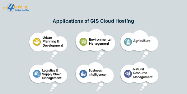
Applications of GIS Cloud Hosting
Urban Planning and Development
In order to make well-informed judgments regarding urban growth, urban planners employ cloud-based GIS to assess land use, transportation patterns, and demographic data. It enables the production of 3D models for infrastructural optimization and city expansion simulation.
Environmental Management
Cloud-based GIS makes it easier to keep an eye on changes in the environment, including pollution levels, natural catastrophes, deforestation, and climate change. Real-time processing and analysis of satellite-derived remote sensing data allows for quick reaction to environmental emergencies. Disaster relief groups and governments may anticipate natural catastrophes like hurricanes, cyclones, earthquakes, forest fires, and more in advance and make necessary preparations by analyzing trends and data. Evacuation planning, resource allocation, and damage assessment may all be accomplished efficiently using real-time mapping and analysis.
Agriculture
GIS cloud hosting can have a major impact on the agricultural industry and optimize the entire value chain. Precision farming relies on cloud-based GIS to streamline crop management. Farmers can analyze soil quality, weather conditions, and historical data to make data-driven decisions about planting, irrigation, and harvesting. This can help boost their yearly produce and prevent agriculture of the wrong crops in the wrong season.
Logistics and Supply Chain Management
Logistics is a vital sub-function of the supply chain industry and can cause various disruptions in global trade if demand-supply equilibrium is not maintained. Logistics companies therefore use GIS in the cloud for route optimization, fleet management, and real-time tracking of shipments. It increases efficiency and reduces transportation costs while enabling organizations to manage their logistics effectively.
Business Intelligence
Companies use location-based data and spatial analysis to gain comprehensive insights into customer behavior, market trends, and sales territory optimization. Cloud-based GIS tools enable the integration of geospatial data into business intelligence dashboards. This can help businesses harvest untapped markets and monitor their business performance at various locations which can eventually improve their business significantly.
Natural Resource Management
Because natural resources are always running out, it’s important to use them sustainably to prevent total depletion and exhaustion. Forests, waterways, and animal habitats are examples of natural resources that governments and organizations track, monitor, and manage using GIS-based systems and data. This promotes sustainable development and aids in conservation and sustainable resource management.

Conclusion
In summary, GIS cloud hosting is a revolutionary force that is redefining the way that geographic data is handled and applied in a variety of businesses. GIS cloud hosting improves productivity, sustainability, and decision-making with characteristics including high scalability, accessibility, and seamless collaboration. GIS is elevated to new heights by its integration with cloud technology, which promotes creativity and agility. The market’s noteworthy expansion highlights how important it is, especially for industries like government and natural resources. The future of spatial data analytics will be shaped by the rapid evolution of GIS cloud hosting and its role in urban planning, environmental management, agriculture, logistics, and business intelligence.
FAQs
Q1 How does GIS Cloud hosting differ from traditional Cloud Hosting?
Answer: Geographic Information System requirements are the only thing that GIS cloud hosting addresses, setting it apart from standard cloud hosting. GIS cloud hosting, as opposed to general cloud hosting, is designed specifically for managing geographical data and offers advantages including high scalability, seamless collaboration, and tools specific to geospatial research. With its speed optimization for GIS applications, it guarantees effective management of big datasets and real-time mapping. This specialty sets GIS cloud hosting apart, providing improved capabilities for sectors like agriculture, urban planning, and environmental management that depend on geographic data.
Q2 Does GIS cloud hosting consume higher resources?
Answer: GIS cloud hosting may consume more resources than traditional hosting due to the nature of Geographic Information System applications. GIS involves processing and analyzing large datasets, performing complex geospatial computations, and rendering real-time maps, which can be resource-intensive. The demand for storage, computing power, and bandwidth may be higher to ensure smooth functioning. However, the scalability features of GIS cloud hosting allow users to adjust resources based on their needs, optimizing efficiency and preventing unnecessary resource consumption during periods of lower demand.
Q3 Is GIS cloud hosting safe?
Answer: Yes GIS cloud hosting is highly safe and secure. Strong security precautions are put in place by cloud hosting companies, and these features include frequent backups, access limitations, and data encryption. The general security of GIS cloud hosting is improved by the utilization of safe data centers with network and physical security measures. Like with any technology, users must, nonetheless, adhere to recommended practices for data security, which include creating strong passwords, putting access limits in place, and keeping up with security upgrades. The security of GIS data saved in the cloud is further guaranteed by adherence to industry standards and laws.